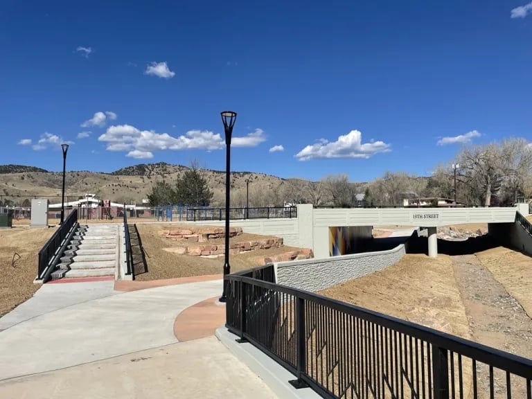
On the morning of April 22, a small crowd gathered at Crest View Elementary on Sumac Avenue before the first bell. It was Bike to School Day. It was also Earth Day. And it was the ribbon cutting for a new underpass that lets kids cross 19th Street without ever touching traffic. City staff were there. So were Transportation Advisory Board members and a few city council representatives. A group of students climbed onto bikes at 9 a.m. and rode the new route to Centennial Middle School, tracing the corridor the city had just spent two years rebuilding.
If you live in Norwood or along the Violet corridor and noticed the construction cones finally disappeared this spring, the corridor now includes a bike lane and a safer crossing. The underpass at 19th and Fourmile Canyon Creek also serves a flood-mitigation purpose, which shaped the project's timeline. Sidewalks and other improvements for Crest View families were built alongside that work.
What Actually Opened This Spring
The finished corridor runs along 19th Street between Norwood and Sumac avenues, with the new underpass itself connecting Tamarack and Upland. Here's what's physically different if you drive, walk, or bike that stretch now:
- A grade-separated bicycle and pedestrian underpass at Fourmile Canyon Creek, with LED lighting that stays on around the clock
- A rebuilt and widened 19th Street bridge over the creek
- Replacement of the Wonderland Creek culvert to meet current floodplain standards
- A buffered bike lane replacing the old on-street shoulder
- New sidewalk sections that close gaps in the existing network
- Upgraded transit stops, signage, and pedestrian crossings
- Speed cushions along the corridor to slow vehicle traffic without slowing emergency response
None of that reads like a small project, and it wasn't. Major construction started in March 2024 and wrapped this spring, but the planning stretches back much further. The city's own Community and Environmental Assessment Process for this stretch of Fourmile Canyon Creek, the document that set the technical direction for everything that got built, was adopted by city council in April 2012.
The Project Timeline
Construction residents saw began recently, but the planning record starts much earlier.
Year | What happened |
|---|---|
2012 | City council adopts the CEAP for Fourmile 19th to 22nd Streets, setting the technical framework |
August 2018 | Transportation Advisory Board feedback prompts two additional design alternatives tied to the Low-Stress Walk and Bike Network Plan |
Late 2018 to summer 2019 | City studies the Wonderland Creek floodplain to understand permit requirements before design can proceed |
March 2024 | Major construction begins on both the underpass and the multimodal corridor |
Spring 2026 | Both projects finish and travel lanes fully reopen |
April 22, 2026 | Ribbon cutting and community bike ride from Crest View Elementary to Centennial Middle School |
Fourteen years from framework to finished pavement is not unusual for a Boulder infrastructure project that touches a floodplain, but it does mean the construction fatigue residents felt over the past two years was the tail end of something the city had been positioning since before most current Crest View students were born.
How the Project Was Funded
The funding sources help explain how the project came together. The underpass wasn't funded as a school safety improvement. It was funded through the city's Utilities Department Stormwater Fund, the Community, Culture, Resilience and Safety Tax, and the Mile High Flood District. That's flood infrastructure money, the same category that pays for culvert replacement and floodplain capacity work anywhere else in the city.
The multimodal piece, the sidewalks and bike lane and transit stops, drew on a separate budget: the Colorado Department of Transportation's Transportation Alternatives Program and the Safe Routes to School program. That's safety and mobility money, tied to getting kids walking and biking to school without conflict.
The two funding streams supported distinct parts of a single construction project. The city needed to replace a culvert and widen a bridge to meet floodplain requirements, and the grade-separated path for pedestrians and cyclists was added as part of that construction. That's why the timeline reads the way it does. Floodplain studies had to finish before design could lock in, because the flood requirements set the physical envelope everything else had to fit inside.
Broadway Is Next
The city's plans for the North Broadway reconstruction project, covering the segment from Violet to US 36, already call for adding flood capacity features to a separate underpass at Fourmile Canyon Creek where it crosses Broadway itself, just blocks from where the 19th Street work wrapped up.
That Broadway underpass carries a caveat worth knowing if you're tracking the corridor. The city has been direct that it won't function at full flood capacity until additional downstream improvements are completed, and in the meantime a flow restriction device will be installed to mimic current flood conditions rather than the improved ones. In plain terms, the crossing will exist, but the floodplain benefit it's designed to eventually provide is staged behind work further downstream that hasn't happened yet.
For anyone in Norwood-Violet watching construction schedules, the Broadway project is another planned crossing over this creek. It pairs floodplain work with multimodal improvements on a corridor that runs directly through the neighborhood rather than along its edge.
What Changes on Your Actual Route
Set the funding mechanics aside for a moment and think about what this means for a Tuesday morning. If your kids attend Crest View Elementary, the walk or bike ride from anywhere west of 19th Street no longer requires a street crossing with cars in the mix. That underpass connects directly toward Crest View Park, which sits next to the school and includes a wetland classroom called The Habitat, built in August 2024 with fifth graders who helped design a birdwatching space called The Nest as part of the project.
If your regular loop includes biking toward Centennial Middle School, you're now riding the same route city staff and students traced on April 22, protected by the buffered lane rather than sharing a shoulder with traffic. And if you've been avoiding 19th Street altogether because of two years of lane closures and construction noise, that period is over. The corridor is open, the landscaping is filling in, and the speed cushions are doing what they're designed to do without slowing down anyone responding to an emergency.
The neighborhood got a safer school route. The creek got flood capacity it needed regardless. Both were true reasons for the project, but only one of them explains why it took fourteen years and two separate funding streams to make it happen.
If you're weighing what a corner of Norwood-Violet like this one is actually worth, infrastructure timelines like this one are part of the real picture, not just the finished sidewalk. Debby Caplin tracks these kinds of neighborhood-level changes across Boulder's core neighborhoods, and pairs that knowledge with design-informed guidance for anyone buying or selling here. Reach out for an instant home valuation and a design consult to talk through what a specific address in this corridor is actually worth today.